Skip to content

MENUMENU
  • Home
    • Background and History
    • Overview Map
    • Program Organization
    • Program Documents
  • Projects
    • Water Management
      • Friant-Kern Canal Restoration Project
      • Madera Canal Capacity Restoration Project
      • Reverse Flow Facilities
      • Recapture and Recirculation
      • Groundwater Banking Projects
    • Restoration
      • Reach 2B and Mendota Pool Bypass
      • Reach 4B and Eastside Bypass
      • Arroyo Canal Fish Screen and Sack Dam Bypass Project
      • Gravel Pit Isolation
      • Reach O Levee Improvements
  • Science
    • Study Plans
    • Reports
    • Data Download
    • Science Meeting
    • Subsidence Monitoring
    • Habitat
  • Flows
    • Flow Conditions
    • Surface Water
    • Groundwater Monitoring
    • Water Quality
    • Unreleased Restoration Flows
    • RA Recommendations
    • Seepage Projects
    • Levee Stability / Channel Capacity
  • Fish
    • Reintroduction Activities
    • Monitoring Activities
    • Conservation Facility
  • Get Involved
    • Recent Stories
    • Newsroom
    • Involvement Opportunities
    • Field Advisories
    • Keep Me Informed
    • Related Links
    • General Outreach
San Joaquin River Restoration Program > San Joaquin River Restoration Program Map

San Joaquin River Restoration Program Map

#7 - Merced Confluence Interactive Link #6 - Washington Road Interactive Link #5 - Near Dos Palos Interactive Link #4 Mendota Pool Interactive Link #3 Chowchilla - Below Bifurcation Structure interactive Link #2 Gravelly Ford Interactive Link #1 Friant Dam Release interactive link

sjrrp-map

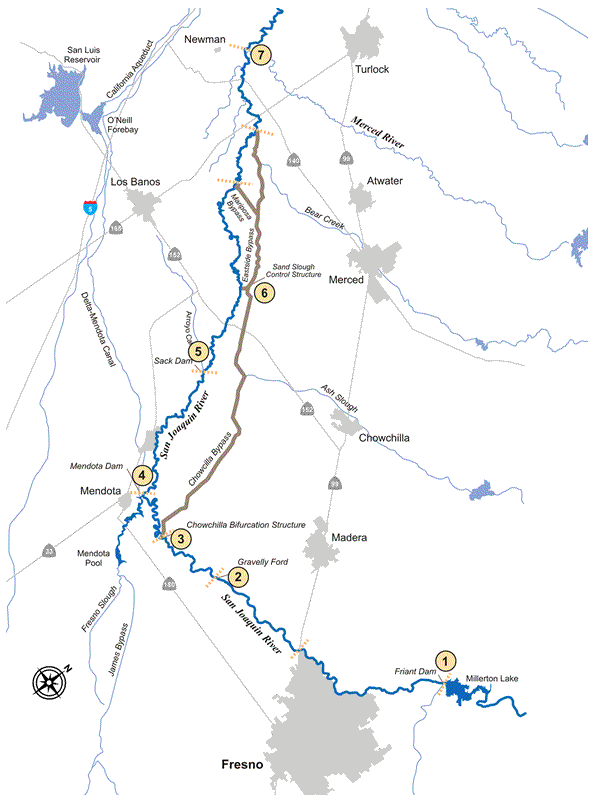
Monitoring Points along the SJ River
1
Friant Dam Releases – Millerton Lake Daily Operations Report.
2
Gravelly Ford (CDEC)
3
Below Bifurcation Structure (CDEC)
4
Mendota Pool (CDEC)
5
Sack Dam (CDEC)
6
Washington Road
7
Confluence of Merced River (USGS)
  • Home
  • Projects
  • Science
  • Flows
  • Fish
  • Get Involved
Copyright © 2025 San Joaquin River Restoration Program. All Rights Reserved.
Contact Us
Top
San Joaquin River Restoration Program
  • Home
    • Background and History
    • Overview Map
    • Program Organization
    • Program Documents
    • Back
  • Projects
    • Restoration
      • Reach 2B and Mendota Pool Bypass
      • Reach 4B and Eastside Bypass
      • Arroyo Canal Fish Screen and Sack Dam Bypass Project
      • Gravel Pit Isolation
      • Reach O Levee Improvements
      • Back
    • Water Management
      • Friant-Kern Canal Restoration Project
      • Madera Canal Capacity Restoration Project
      • Reverse Flow Facilities
      • Recapture and Recirculation
      • Groundwater Banking Projects
      • Back
    • Back
  • Science
    • Study Plans
    • Reports
    • Data Download
    • Science Meeting
    • Subsidence Monitoring
    • Habitat
    • Back
  • Flows
    • Flow Conditions
    • Surface Water
    • Groundwater Monitoring
    • Water Quality
    • Unreleased Restoration Flows
    • RA Recommendations
    • Seepage Projects
    • Levee Stability / Channel Capacity
    • Back
  • Fish
    • Reintroduction Activities
    • Monitoring Activities
    • Conservation Facility
    • Back
  • Get Involved
    • Recent Stories
    • Newsroom
    • Involvement Opportunities
    • Field Advisories
    • Keep Me Informed
    • Related Links
    • General Outreach
    • Back