
Water Quality includes a program of real-time telemetry, generally with 15-minute reporting to the California Data Exchange Center. In addition, the SJRRP initiated a program of manual water quality constituent measurements.
Real-time Telemetry
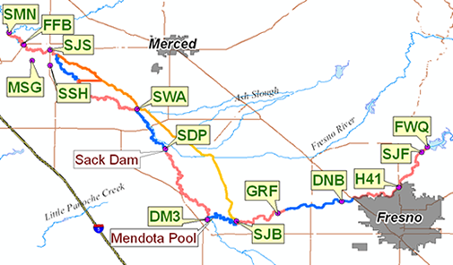
| CDEC Station | Temperature | EC | DO | Turbidity | pH | Chlorophyll |
| FWQ - At Friant Dam | FWQ | FWQ | FWQ | FWQ | FWQ | FWQ |
| SJF - Below Friant | SJR | SJF | ||||
| H41 - Highway 41 | H41 | H41 | ||||
| DNB - Donny Bridge (Rd 32) | DNB | DNB | ||||
| GRF - Gravelly Ford | GRF | GRF | GRF | GRF | GRF | GRF |
| SJB - Below Bifurcation | SJB | SJB | SJB | SJB | SJB | SJB |
| DM3 - Delta Mendota Canal Check 21 | DM3 | DM3 | ||||
| SDP - Near Dos Palos | SDP | SDP | SDP | SDP | SDP | SDP |
| SWA - Washington Road | SWA | SWA | SWA | SWA | SWA | SWA |
| SJS - Stevinson | SJS | SJS | ||||
| SSH - Salt Slough | SSH | SSH | ||||
| FFB - Fremont Ford Bridge | FFB | FFB | ||||
| MSG - Mud Slough | MSG | MSG | ||||
| SMN - Near Newman | SMN | SMN | SMN |
Measurements
In addition to the gaged stations described above, the SJRRP took measurements of water quality parameters at a variety of additional locations.
Temperature Atlas
- Millerton Lake Temperature Atlas (pdf, 7.2 MiB)
Reach 1A Temperature Atlas (pdf, 41.3 MiB)
Reach 1B Temperature Atlas (pdf, 4.0 MiB)
Reach 2A Temperature Atlas (pdf, 13.7 MiB)
Reach 2B Temperature Atlas (pdf, 9.1 MiB)
Reach 3 Temperature Atlas (pdf, 7.4 MiB)
Reach 4A Temperature Atlas (pdf, 10.1 MiB)
Reach 4B1 Temperature Atlas (pdf, 5.9 MiB)
Reach 4B2 Temperature Atlas (pdf, 3.4 MiB)
Reach 5 Temperature Atlas (pdf, 12.0 MiB)
Temperature Atlas Graph: 2010 (pdf, 8.0 MiB)
Temperature Atlas Graph: 2011 (pdf, 7.1 MiB)
Temperature Atlas Graph: 2012 (pdf, 2.7 MiB)
Temperature Atlas Graph: Past - 2009 (pdf, 14.6 MiB)
Water Quality Measurements
SJRRP measurements of total suspended solids, EC, pH, Turbidity, DO, bacteria, trace elements and pesticides at eight sites have been added to the Bureau of Reclamation Water Quality Database. Query All Program Information, Station Description field for “Interim Flows”.
Monitoring is organized according to the Interim Flow Water Quality Monitoring Plan.
Seepage Management Projects
Reclamation conducts water quality monitoring to establish the existing (baseline) quality of San Joaquin River (SJR) surface water in the vicinity of anticipated seepage projects in Reach 3 and Reach 4 of the Restoration Area, of surface water within irrigation canals that are potential receiving bodies for SJR seepage, and of groundwater in lands adjacent to the study reaches.
- WQ Report SMP 201212 (2.7 MiB)
- WQ Report SMP 201305 (2.7 MiB)
- WQ Report SMP 201512 (2.7 MiB)
- WQ Report SMP 201703 (1.0 MiB)
- WQ SMP Tables and Data - Summary (0.3 MiB)
- WQ Report SMP 201805 (0 B)