
The Program uses a variety of tool in order to predict, as accurately as possible, the volume of water available for Restoration efforts. Some of these techniques are listed below.
- Snowpack
Over two-thirds of the San Joaquin River runoff (the amount of water from melting snow and rain) is derived from snowpack. As such, accurately estimating how much runoff will result from the watershed’s snowpack is critical to understanding runoff into Millerton Reservoir. The more accurate the runoff prediction, the more accurately agencies can manage the available water supply for environmental flows in early spring or irrigation water in late spring and summer. For over 70 years, runoff forecasts have relied upon manual snow course measurements and historic relationships between these stations and watershed production. Over the most recent 30 years, snow course measurements have been augmented with automated snow stations (or “snow pillows”) that relay snowpack conditions to scientists. Despite substantial effort and expense, this existing network is limited by the watershed’s high elevation topography, accessibility and maintenance challenges, and a changing climate that are skewing predictability.Excedance forecasts use snowpack measurements to determine future runoff.
Below are some of the measurement stations used to help generate forecasts.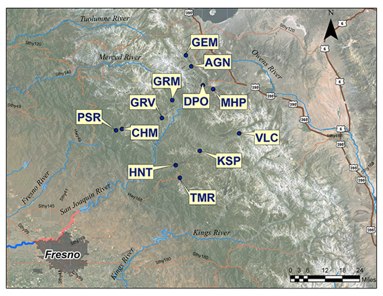
| Station | CDEC Code | Elevation |
| Volcanic Knob | VLC | 10050 |
| Agnew Pass | AGP | 9450 |
| Kaiser Point | KSP | 9200 |
| Green Mountain | GRM | 7900 |
| Devil's Postpile | DPO | 7569 |
| Tamarack Summit | TMR | 7550 |
| Chilkoot Meadow | CHM | 7150 |
| Huntington Lake | HNT | 7000 |
| Graveyard Meadow | GRV | 6900 |
| Poison Ridge | PSR | 6900 |
| Gem Pass | GEM | 10750 |
| Mammoth Pass | MHP | 9300 |
- Airborne Snow Observatory
The Program is working with Friant Water Authority to utilize NASA’s Airborne Snow Observatory (ASO). This newer method for predicting the water content of Sierra snowpack reduces seasonal runoff forecasts to less than a two-percent error.
The San Joaquin Watershed is one of the highest elevation watersheds in California, with almost half of the terrain above 7,500’ elevation and two-thirds of the runoff derived from snowpack. Snow courses and snow pillow are distributed between elevations of 6,800’ and 11,400’, with a substantial amount of the winter snowpack above the highest ground-based sensor. Instead of examining the San Joaquin snowpack through widely scattered point measurements, ASO provides a watershed-wide, high-resolution snapshot and serves as a 21st Century tool to address the demands of modern water management.
Click here and here to read more about ASO.
Other Forecasting Tools:
- DWR Bulletin 120 Water Supply Forecast, used in determining the Friant Division Water Supply Exceedance Forecasts below.
- Bulletin 120 Update
- NOAA Forecast
- NOMADS – NOAA Weather Forecasts
- Flood Control Operations – US Army Corps of Engineers