
Welcome to the SJRRP 2020 VSM Poster Session. Posters can be viewed by clicking the image to the left of the title.
On Wednesday, Oct. 14 from 1:30 p.m. – 2:30 p.m. poster authors will be hosting live chatrooms to discuss their work and answer questions. To visit a chatroom, click on the orange “Join ” button to the right of each poster title. To visit other chatrooms, exit the one you are in and return to this page. Links to these chatrooms will be active on Oct. 14. Note: Chatrooms are being hosted on GoToMeeting, which functions best on Google Chrome.
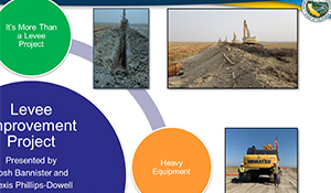
Levee Improvement Project to Increase Restoration Flows
Alexis Phillips-Dowell and Joshua Bannister, California Department of Water Resources
A main goal of restoring the San Joaquin River is to achieve a self-sustaining population of Chinook salmon. To achieve this goal, salmon need enough flow to provide a viable migration pathway. DWR is completing a 2-mile levee improvement project on the Eastside Bypass. This levee improvement will allow for the increase in Restoration Flows in the Eastside Bypass, which is the limiting channel capacity reach along the current Restoration flow path. The project includes the installation of a slurry wall in the levee and the replacement of six culverts. DWR initiated construction in May 2020 and hopes to complete the work by the end of October 2020. This presentation will include photos and short videos that focus on the construction process including highlights of the installation of the slurry wall and the replacement of the culverts.
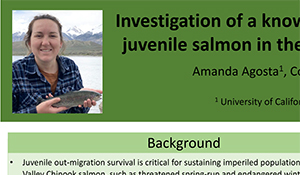
Investigation of a known mortality hotspot for out-migrating juvenile salmon in the Sacramento-San Joaquin River Delta
Amanda Agosta, University of California, Davis
Several years of acoustic telemetry data suggests Franks Tract, a 3000-acre flooded island in the south Delta, increases mortality for out-migrating juvenile salmon. To understand juvenile salmon ecology in this area, we studied relative predation risk of juvenile salmon using tethering experiments. Additionally, we conducted an experimental release into Franks Tract of 100 juvenile spring-run Chinook salmon tagged with acoustic transmitters. We hypothesize that entrainment into Franks Tract increases mortality for salmon via predation by non-native piscivores. Analysis of tethering data is in progress; however, provisional telemetry results suggest poor survival overall. However, outmigration survival is notoriously low for fish routing through the interior delta and that some fish survived to ocean entry suggests Franks Tract is not a complete sink. Understanding spatially-explicit mortality risks may facilitate adaptive management strategies for salmon in the Central Valley.
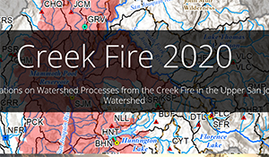
Potential Ramifications on Watershed Processes from the Creek Fire in the Upper San Joaquin River Watershed
Andrew Minks, Bureau of Reclamation
Upper watersheds, or headwaters, are the foundation of a river. This is especially true with the San Joaquin River, which originates in the high-elevation Eastern Sierra Nevada mountain range, flowing west to the San Joaquin Valley floor. Whatever happens in the upper watersheds affects everything downstream. Wildfires are common in western watersheds and are a natural form of disturbance in forests. Fire can provide long-term benefits to forest and watershed health; however, high intensity or large catastrophic wildfires can result in significant increases in runoff and erosion, which can negatively impact water quality and make predicting runoff more difficult within a watershed. The Creek Fire, which started on September 4th, 2020, has burned a significant portion of the upper watershed that feeds Millerton Lake, the water source for the San Joaquin River Restoration Program (SJRRP). This Story Map explores the upper San Joaquin River watershed, the Creek Fire, and the potential ramifications of the fire on the upper watershed and the SJRRP.
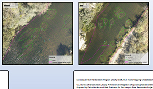
Using Drones to map Salmon Redds and Habitat on the San Joaquin River
Austin Hall, California Department of Water Resources
The California Department of Water Resources Fish Passage Improvement program, in support of the San Joaquin River Restoration Program, conducted aerial drone surveys in October 2019 to document the record number of spawning adult spring-run chinook salmon on the San Joaquin River below Friant Dam. We mapped several areas identified by CA Department of Fish and Wildlife boat and snorkel surveys where high numbers of redds were reported. Our objectives were 1) to explore the efficacy of using drones as a non-invasive method for conducting redd counts, and 2) correlate spawning data with habitat features and the results of 2d hydraulic habitat model.
San Joaquin River Restoration Program Gravel Pit Prioritization
Byron Willems, California Department of Water Resources
The San Joaquin River Restoration Program needs to determine the highest priority gravel pits in Reach 1 of the San Joaquin River based on relative impacts to juvenile salmon mortality. The California Department of Water Resources identified Reach 1 pits and their physical characteristics; determined pit effected factors impacting juvenile salmon mortality; developed methods evaluating the factors with physical characteristics; and, assembled a model which resulted in ranking the pits by relative predation. Pit area, volume, and connection flow were also applied to ranking pits by connection and size. Comparison of the predation and size rankings are found to have close agreement with seven pits being in the top 10 pits in both lists. The highest relative impacts list combined the predation and size rankings by including the seven top 10 pits with two pits that have a high ranking from the top 10 in one of the two rankings that may indicate high impacts on juvenile salmon mortality.
Spawning Segregation of Fall-run and Spring-run Chinook Salmon in the San Joaquin River
Emily Flink, U.S. Fish and Wildlife Service
The San Joaquin River Restoration Program (SJRRP) focuses on establishing populations of spring-run (SR) and, if conditions permit, fall-run (FR) Chinook salmon in the San Joaquin River Restoration Area. Thus, the potential exists for these populations to hybridize or interfere with successful spawning through redd superimposition. The SJRRP is responsible for preventing, to the greatest extent possible, hybridization between FR and SR and superimposition of FR on SR redds. Spawning surveys conducted in the Restoration Area for FR (2013-2016) and SR (2016-2019) have provided information on the overlap of spawning habitat between the runs. A yearly average of 75% of FR and only 5% of SR spawned lower than a proposed SJRRP segregation weir location. These findings suggest that segregation of the runs using a segregation weir to prevent hybridization and superimposition may be possible. In this poster, we show the spatial overlap in spawning sites and possible segregation weir locations.
Quantifying Spring-run Chinook Spawning Habitat Using GIS
Enoch J. Tham and Andy J. Shriver, California Department of Fish and Wildlife
Spring-run Chinook salmon were extirpated from the San Joaquin River by 1950 after the construction of Friant Dam. The San Joaquin River Restoration Program (SJRRP) seeks to restore a population of this threatened species downstream of their historic spawning grounds. A sufficient quantity of spawning habitat is critical to meet population targets. Using bathymetric, baseflow hydraulics, and mapped substrate data in a GIS environment, we calculated the area of available spawning habitat within Reach 1A at tenths of a river mile. Based on life-stage temperature limits, modeled and observed river temperatures, the SJRRP believes spring-run Chinook salmon will concentrate spawning activity within the upper five to ten river miles below Friant Dam. Our analysis of suitable spawning depths, velocities, and substrate, results in available spawning habitat of 38,100 m2 and 114,800 m2. Additionally, these results locate areas where spawning habitat may be a future focus for augmentation.
Riparian Brush Rabbit (Sylvilagus bachmani riparius) Recovery Along the San Joaquin River
Haley Mirts, River Partners
The riparian brush rabbit (Sylvilagus bachmani riparius) is the Central Valley’s most endangered mammal. Endemic to the riparian forests of the San Joaquin and Stanislaus river corridors, the delisting of the species is highly dependent on the restoration of riparian habitats in the San Joaquin Valley. Since 2010, River Partners has worked in conjunction with the riparian brush rabbit working group, a collaborative of non-profit, academic, private and agency organizations, to build and restore riparian brush rabbit habitat using an adaptive management framework. Through this successful partnership, the species has been able to withstand increasingly severe flooding events, and is poised for new translocation populations within the valley, including Dos Rios Ranch in Stanislaus Co. Ongoing camera trap work at the San Joaquin River National Wildlife Refuge and Dos Rios Ranch provides insights into the next phase of habitat management for this species.
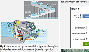
Integrating Resiliency into the Analysis and Design of Fish Passage Facilities
Jean Castillo, National Marine Fisheries Service
Climate change impacts can have both primary and secondary effects on infrastructure, river hydrology and water temperatures affecting salmonid populations and other NOAA trust species. Addressing climate change impacts preemptively allows for Management actions that can address safe, timely and effective fish passage. This is achieved by building resiliency into the planning and design of facilities and reduce the risk of failure for water development structures as it relates to fish passage. For example, larger peak flow events are due to an increase in heavy rainstorms and an increase in the proportion of precipitation falling as rain versus snow. Both in turn result in increased stream power and bank erosion and altered hydrographs and reservoir storage. Looking at the changes in future hydrology may indicate a need for a larger crossing facilities to accommodate the changes in stream geomorphology to ensure the project will meet fish passage requirements in the future. A key requirement of the National Marine Fisheries Service (NMFS) is to advise water resource managers, stream crossing, and habitat project proponents on how to design a fish passage project to meet NMFS’ statutory requirements. Currently, none of the NMFS guidelines including the South West Region (SWR) 2001 guidelines, the NMFS’ 2011 Anadromous Salmonid Passage Facility Design (NMFS 2011) document and the NOAA Fisheries West Coast Region Anadromous Salmonid Passage Design Guidelines (Draft 2015/2018/2020 Guidelines) that updates the NMFS (2011) document addresses climate change. Importantly, these guidelines do not provide project proponents and NMFS staff with any consistent, practical procedures on how to address and incorporate identified climate impacts into fish passage facility design for anadromous salmonids. This poster presentation highlights efforts by NOAA Fisheries to develop guidance to incorporate climate change risks into these key infrastructure planning arenas, including appropriate choices of climate information and how to design a project to support NMFS’ statutory requirements.
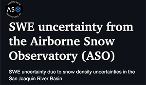
SWE uncertainty from ASO due to snow density uncertainties in the San Joaquin River Basin
Kat Bormann, Airborne Snow Observatories Inc.
Accurate estimates of the water contained within the snowpack provide a solid foundation for seasonal volumetric streamflow forecasts. The Airborne Snow Observatory (provided by ASO Inc.) complements its snow albedo measurements with the combination of spatially-distributed snow depth measurements and modeled snow density maps (from iSNOBAL) to estimate the water content of the snowpack (SWE) in near real time. The ASO snow depth measurements have an accuracy of ~1 cm at 50 m spatial resolution. Therefore, the uncertainty in the ASO SWE products is due primarily to the uncertainty in the snow density estimates. While these snow density fields are not directly measured by ASO, our best measurement campaigns suggest uncertainties in density at the 50 m resolution of less than 5%. In this talk, we will demonstrate the sensitivity of SWE volumes in the San Joaquin basin to snow density using a case study.
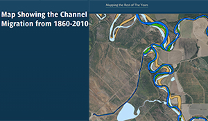
Historic channel changes in the lower San Joaquin River
Lambert Ngenzi, River Partners
As part of a grant from the California Department of Water Resources Riverine Stewardship Program to remove concrete rubble from the banks of the San Joaquin and Tuolumne rivers along River Partners’ Dos Rios and Hidden Valley ranches, River Partners evaluated historic channel alignments from the 1930’s to present day using historical imagery and topographic maps. This record complements historic channel mapping from the 1860’s to the 1930’s previously completed, thereby creating a record from the 1860’s to present day. This evaluation will help inform the project planning and design process and provides a reference for others. In addition, River Partners analyzed and quantified river meander migration and subsequent habitat formation in a small unarmored reach of the Tuolumne River along the Dos Rios Ranch. This exercise will provide estimates of erosion and migration rates that can be used to inform potential effects of rubble removal.
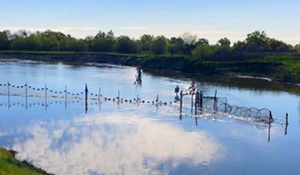
There and Back Again: Green Sturgeon Passage
Meiling Colombano, National Marine Fisheries Service
In April 2020, a green and a white sturgeon were incidentally captured in a fyke trap as part of adult salmonid monitoring in the San Joaquin River near the confluence with the Merced River. This is the first documented green sturgeon in the main stem San Joaquin and in the Restoration Program Area. Given the numerous fish passage projects that will be implemented by the Program in the upcoming years, this talk will provide a general overview of the current knowledge for adult sturgeon passage. In particular, this talk will 1) briefly outline the life history of sturgeon, with an emphasis on green sturgeon; 2) outline key points in the NMFS 2018 Green Sturgeon Recovery Plan related to the San Joaquin River; and 3) describe the current knowledge and recommendations for adult green sturgeon passage, and some suggested monitoring for the San Joaquin River. The associated poster will include information from the pop-up talk, and include more specific recommendations for adult green sturgeon passage.
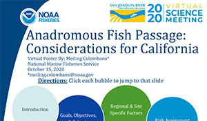
Anadromous Fish Passage: Considerations for California
Meiling Colobano, National Marine Fisheries Service
The Pacific Northwestern states span a range of weather patterns, ecosystems, geology, and hydrology. In particular, California’s climate varies widely between the northern and southern portions of the state. California’s anadromous fish species have evolved to those differences in hydrology and associated habitats throughout the State. The precipitous decline in populations of several anadromous fish species, both federally listed and not, has spurred various fish passage projects throughout the state. For a fish passage project to be successful, the designs should consider not only engineering criteria, but also biological goals and objectives. This poster outlines several site-specific factors that need to be considered during development of biological goals for a project, and prior to the finalization of fish passage designs. These factors include: hydrology, geology, climate, existing and future anthropogenic limiting factors, site specific ecology, and fish biology.
Adult Spring-run Chinook Salmon Return Monitoring in the San Joaquin River
Nick Fisher and Paul Carrillo, U.S. Fish and Wildlife Service
The San Joaquin River Restoration Program is working to reestablish a self-sustaining population of spring-run Chinook salmon (Oncorhynchus tshawytscha). The goal of our study is to monitor the abundance and temporal distribution of adult salmon returning to Reach 5 of the San Joaquin River Restoration Area. Salmon detections are used to inform management decisions, such as initiating trap and haul of adults past migration barriers to spawning grounds in Reach 1. Spring-run Chinook salmon return monitoring was conducted in 2016, 2018, and 2020 using a net weir and VAKI RiverWatcher infrared fish counter. Over 1,900 fish passages were detected during the 3 sampling years; none of the passages were identified as salmonids. Passage numbers were highly variable among sampling years due to environmental factors affecting study length. As long as passage barriers preclude volitional returns to spawning grounds, return monitoring and trap and haul efforts will be needed to meet SJRRP goals.
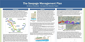
The Seepage Management Plan
Regina Story, Bureau of Reclamation
The San Joaquin River Restoration Settlement Act, Public Law 111‐11, requires the Secretary of the Interior to describe a seepage monitoring program as part of Settlement implementation. The Seepage Management Plan (Plan) was developed over several years and is a dynamic and adaptive document, incorporating new data and stakeholder input. The Plan addresses material adverse impacts to third parties from groundwater seepage caused by Restoration Flows. The Plan aims to achieve this through an extensive monitoring network and evaluation of any recommended flow changes. The Program maintains a groundwater monitoring well network of 200+ wells to avoid exceedance of agricultural and historical groundwater thresholds. This allows for the release of Restoration Flows within channel capacity constraints while seepage projects are completed. These projects can be realty transactions or physical projects. The Program continues seepage projects to achieve the Settlement objective of 4,500 cfs.
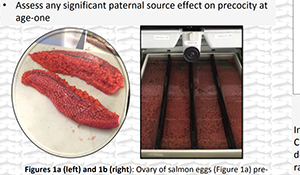
The Effects of Incubation Temperature, Feeding Regime, and Parentage on Precocious Maturation of Spring-run Chinook Salmon
Stephen Winsor, California Department of Fish and Wildlife
Salmonid populations in the San Joaquin River have been in decline for decades, making hatchery practices that combine conservation strategies with targeted research essential to optimize reintroduction success. Hatchery populations generally exhibit a higher incidence of precocity in produced males than in natural populations. This can potentially skew sex ratios for a particular year class having impacts on the natural population’s genetics and result in less returning adults. However, optimal practices have yet to be established to lower the incidence of precocity in hatchery reared male spring-run Chinook salmon. To further assess this, we exposed fertilized salmon eggs to two temperature regimes and two subgroups of high and low feeding regimes upon exogenous feeding. Warm incubation and high feed rate had significant effects on precocity at year one and varied largely due to parentage. Optimizing Chinook rearing techniques is critical to maximize successful reintroduction.
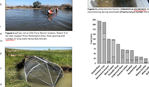
Capture of Uncommon Fishes in the San Joaquin River Restoration Program Restoration Area
Zak Sutphin and Shaun Root, Bureau of Reclamation
Fisheries monitoring activities by Bureau of Reclamation biologists working for the San Joaquin River Restoration Program (SJRRP) have been occurring in the lower reaches of the SJRRP Restoration Area (RA) since 2010. These efforts have focused largely on targeting adult salmonids (e.g., Steelhead Monitoring Plan, Chinook Salmon Monitoring and Adult Trap and Haul) using both active and passive techniques. Fish captured with fyke nets and traps during monitoring have provided new records of occurrence for two rare species: green sturgeon (Acipenser medirostris; captured 4/11/20; Root et al. 2020 In Press) and Chum salmon (Oncorhynchus keta; captured 12/11/13 and 12/11/17; Root et al. 2015), evidence of returning adult spring-run Chinook salmon (Oncorhynchus tshawytscha) to the RA for the first time in nearly a century, and further evidence of adult white sturgeon (Acipenser transmontanus; captured 03/27/19 and 4/12/20) using the lower reaches of the RA.
2019-20 San Joaquin River Restoration Program Steelhead Monitoring Plan
Zak Sutphin and Shaun Root, Bureau of Reclamation
Instream barriers have led to the reported extirpation of Central Valley (CV) steelhead upstream of the SJR-Merced River confluence (i.e., the San Joaquin River Restoration Program (SJRRP) Restoration Area). In accordance with the 2012 SJRRP Record of Decision and National Marine Fisheries Service Biological Opinion (2011/05814:ELS), the U.S. Bureau of Reclamation annually monitors for presence of CV steelhead in the Restoration Area when Restoration Flows are being released. In 2019-20, Reclamation completed the seventh year of the SJRRP Steelhead Monitoring Plan (SMP). A combination of fyke netting/trapping, and raft electrofishing were completed for approximately two weeks, monthly, between December 2019 and April 2020 in Reach 4 and 5 of the Restoration Area. For the seventh consecutive monitoring effort (2012, 2013, 2014, 2017, 2018, 2019, and 2020) since the inception of the SMP, no steelhead were detected.